Counting Ducks: The Inside Story Behind the North American Waterfowl Survey
Posted 2023-06-01 by
Biologists don’t just guess at annual waterfowl numbers. They count ducks and geese individually, often from low-flying aircraft in challenging conditions. Here’s the scoop on the world’s longest-running wildlife survey.
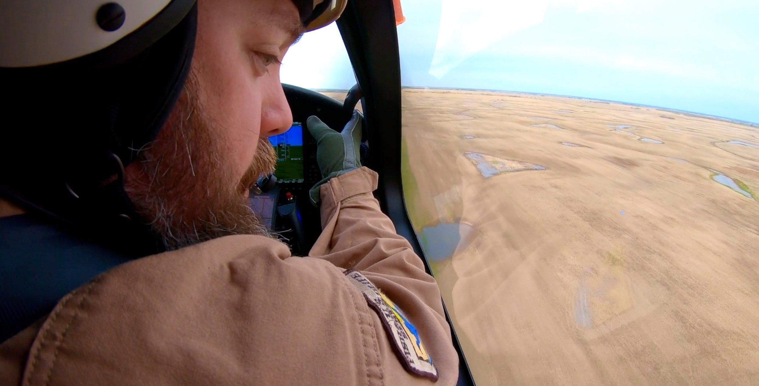
If you think identifying waterfowl at a distance is tough, try doing it at 150 feet high while flying at 100 knots. Photo courtesy of U.S. Fish and Wildlife Service.
Flying at dangerously low altitudes, visiting some of the world’s most remote locales, and operating a secretive government surveillance mission sound like the basis of a pretty cool spy movie. But actually, it’s more Nature Channel than James Bond. Those activities constitute the backbone of the Waterfowl Breeding Population and Habitat Survey, the world’s longest-running wildlife survey, which annually collects critical information for the management and future of ducks, geese and other birds.
The survey, which began in 1947, is conducted each year in May and June by the U.S. Fish and Wildlife Service and Canadian Wildlife Service by ground, airplane, and helicopter across a 2-million-square-mile area including parts of Alaska, Canada, and the north-central United States — the principal waterfowl breeding areas of North America. Its primary focus is to evaluate habitat conditions in Prairie-Parkland Canada and provide information on the spring size and trajectory of 19 duck species or species groups, plus Canada geese, coots, and swans. The information is then used to establish annual waterfowl hunting regulations and provide long-term data for waterfowl conservation.
“It’s important work,” said Brad Pendley, wildlife biologist at Mingo National Wildlife Refuge in Missouri. Pendley served as an aerial biologist observer for five surveys. “A lot of our season dates and population estimates come from these breeding populations. It’s an important survey for us and what we do.”
And if you ask the folks who conduct the survey, it’s also quite an adventure.
How it Works
Groundwork for the survey actually begins in August, when U.S. and Canadian officials start the effort’s administrative paperwork. Then in May, after most waterfowl have reached their breeding grounds, the survey itself begins in earnest.
“We use 11 USFWS aircrews and two service ground crews, along with three Canadian Wildlife Service ground crews and three Canadian aircrews to complete the survey,” said Mark Koneff, chief of the Branch of Migratory Bird Surveys, Division of Migratory Bird Management.
Air crews consist of a pilot-biologist and a biologist observer, both of whom observe and count waterfowl, and then voice-record their observations and relay that data. Ground crews operate only in the prairies, where roads are good. Helicopters are used in some remote areas for intensive surveys. Observers typically sign up for three-year stints, but some — including Pendley — go longer.
“Each crew generally proceeds from south to north in their crew areas, attempting to time survey operations with the progression of spring,” said Koneff, who’s also the survey pilot for the Maine and Atlantic Canada survey area. “Crews attempt to survey areas after most migrating birds have passed through on their way north and local birds are well distributed on breeding territories.”
Crews are constantly on the move, trying to cover their entire regions. The survey duration varies by area, but generally last three to six weeks. “The boreal forest ‘bush’ crew areas typically take longer to complete because of the larger coverage areas, more limited aviation facilities and generally poorer weather,” Koneff said. “The southernmost crews begin the survey in early May, and the northernmost crews finish in the middle of June during a typical year.”
Afterward, officials at the Patuxent Wildlife Research Refuge in Laurel, Maryland, crunch the survey numbers and typically release information on pond counts and breeding duck numbers in August. Data from the survey and other programs goes into a series of population models that ultimately provide recommendations on hunting seasons that maximize opportunity without overstressing waterfowl populations.
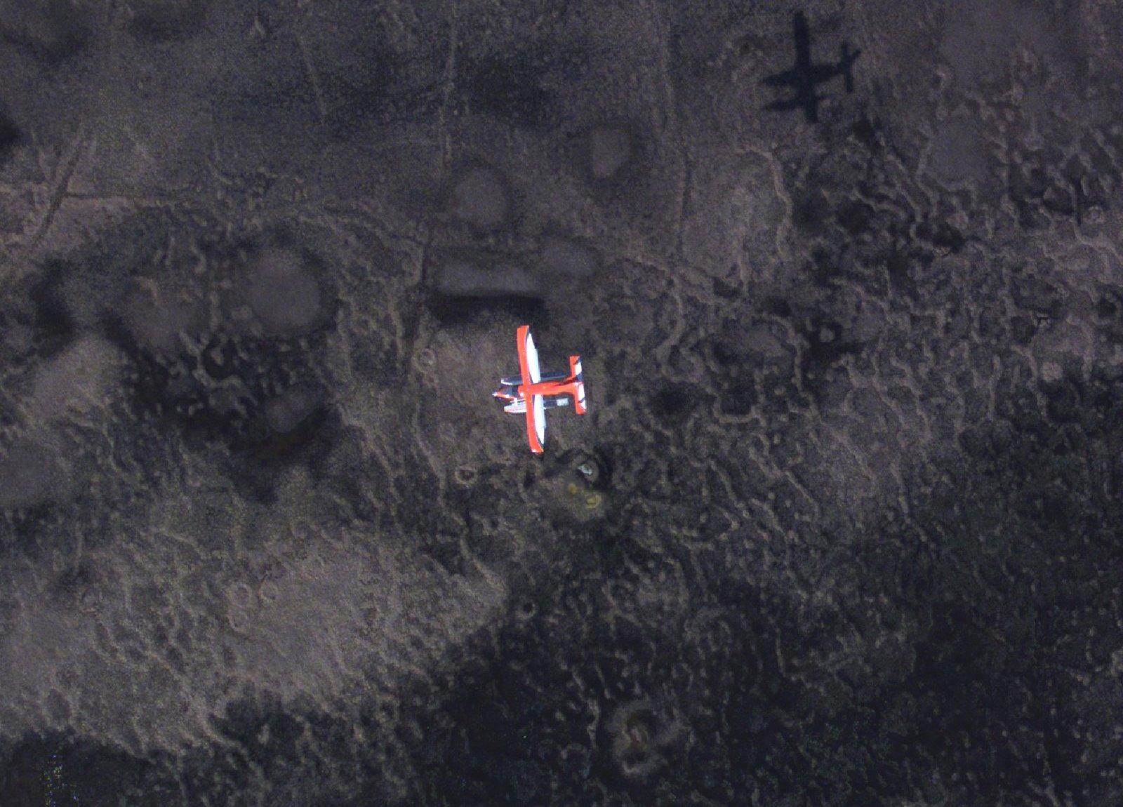
North America’s waterfowl survey covers some of the most remote country in the continent. Pilots must constantly assess risk to navigate many challenges. Photo courtesy of U.S. Fish and Wildlife Service.
Life on the Survey
Because of the survey’s duration and the challenging nature of the work, life on the duck counting trail can be intense. (Pilot-biologists write regular blogs during their time afield: Check them out here:
Koneff said crews typically awaken early, check weather, review survey flight plans and aerial hazards along the route, complete risk assessments, and then file flight plans. If the weather is promising, prairie crews take off early and are done by early afternoon. The routine for boreal forest crews is very similar, but they’re not restricted to morning-only flights, as the challenges of poor weather and logistics necessitate greater flexibility.
Sometimes, even getting airborne can be challenging. Koneff said unpredictable spring weather is obviously the greatest obstacle. “In many areas, the crews might have to sit for a few days to wait out weather systems before continuing,” he said. “In some areas, particularly those in the eastern part of the continent, atmospheric blocking is a common phenomenon and can result in crews being stuck in cold, wet conditions with low clouds and poor visibility for a week or more.”
That’s not the only challenge. In an operation with many moving pieces, there’s a long list of things that can go wrong. “Aircraft maintenance-related problems are particularly challenging in remote locations,” Koneff said. “At times, especially in northern regions, local accommodations might be difficult to obtain, requiring crews to improvise in-field camps or find other solutions, like sleeping in the aircraft. In the West, wildfires are also becoming an ever more challenging aspect of survey operations. Not only can large wildfires cause temporary flight restrictions that might preclude aircrews from accessing some survey areas, the smoke from distant fires can reduce visibility to the point where safe low-level flight is not possible, requiring crews to wait until conditions improve. Finally, people get sick. It’s not uncommon for air and ground crews to suspend operations temporarily to allow for a sick crew member to recover.”
After flights are complete, the workday doesn’t end. Crews spend the afternoon and evening preparing for the next survey, securing lodging, transcribing data and handling other tasks.
“We’d land, secure the plane, find a way back to the hotel or wherever we were staying, and then in the evening, we would transcribe everything we recorded during the day,” Pendley said. “Actually, we’d listen to our voice audio and put that into our database. Every two to three days, we’d try to send (biologists) the data so they could start on it.”
Crews sometimes stay in the same location overnight, but they often move to the next base to prepare to fly another transect. Pendley, for example, said his crew slowly worked westward through their survey area, from Ontario and Quebec to Labrador.
“The planes are, for the most part, amphibious, so we can land on water or land,” he said. “North of most roads, we’d stay at hunting camps, hunting lodges, fishing camps, caribou camps — anywhere we could get a roof, really. On the southern transects, we’d stay at hotels. It varies from crew to crew. The pilots are great. They have a lot of relationships after flying the same areas for years. They know all the folks at the airports, airstrips, and all the lodges, and they really have a great relationship with those folks. Most of the locals are really happy to see them every year when they fly back in.”
Many survey flights might seem like barnstorming adventures, as pilots typically operate aircraft at about 150 feet high at 100 knots (115 mph). At that altitude, they’re constantly on the lookout for hazards. Koneff said pilot-biologists require specialized training to develop and maintain the skills to survive in the low-level environment for standard and emergency operations.
“There were some pretty hilly areas and some pretty tall trees where I was at,” Pendley said. “It was always interesting. It takes a little getting used to be comfortable flying that low for extended periods. The pilot-biologists are used to it. Even the observers get used to it pretty quickly. I’ve heard tales of folks who had air sickness issues and had a hard time with it. We try to make sure that folks aren’t going to have those issues before they sign up and take off.”
And then there’s the matter of trying to count waterfowl while zipping through the air above them. Koneff said air and ground observers, including pilot-biologists, must possess finely honed waterfowl identification skills. “It can take observers that have excellent identification skills from the ground some time to reorient to different cues available from the overhead perspective,” he said. “In addition to the perspective, observers must adjust to imperfect observation conditions, like glare, backlighting and the speed of the aircraft, which affords only seconds to observe each bird. Imperfect observation conditions often require the observer to take in multiple cues in making a species determination.”
Pendley, who’s counted and identified waterfowl as part of his job for years, agreed. “It’s a little different being above the duck instead of at ground level,” he said. “But it comes pretty quickly. You have to be on your toes. That low and at that speed, you have to concentrate on staring down and being ready.”
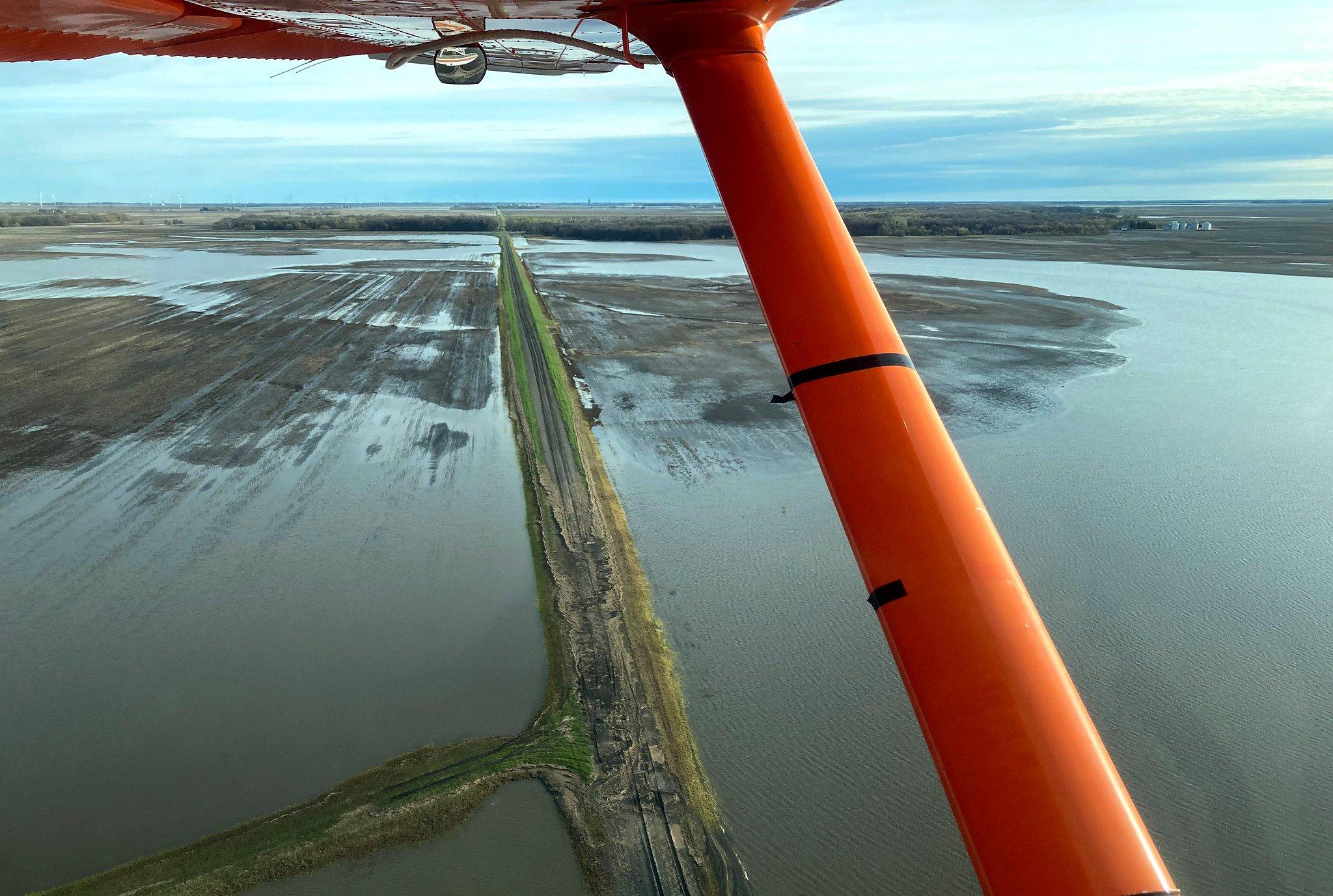
North American Waterfowl Survey crews stay on the move, often completing one transect and then traveling to a new location to undertake another the next day. Photo courtesy of U.S. Fish and Wildlife Serivce.
Conclusion
After the survey is completed, survey staffers begin preparations for the next year, and biologists pore through stats and ultimately release the long-awaited duck numbers and habitat conditions for waterfowlers to digest. And after several weeks living a taxing, often challenging lifestyle, pilot-biologists, observers, and others return to more of a normal routine. Although it might seem like a lot of work to count a few ducks, participants say they wouldn’t have it any other way.
“It was taxing, but I wouldn’t say it was a grind,” Pendley said. “You’re committing three to four weeks every spring. By the time you do all your prep leading up to it and do all the closeouts, it’s a pretty good time commitment. But I know I would go back given the opportunity. I loved doing it. It’s one of the highlights of my career.”