New Kentucky Highway Would Jeopardize Public Duck Hunting Spot
Posted 2024-01-11 by
Conservation groups urge against corridors that would cut through one of the state’s best public waterfowling areas

A property that could be affected by a new highway proposal has been described as one of Kentucky’s best wetlands. Photo by Bill Konway
A study to examine the potential effects of creating a new highway connector through one of Kentucky’s best public wetlands has hunters and other conservationists concerned and confused. The initiative, put forth by the Kentucky Transportation Cabinet, seeks to examine the possible social and economic impacts of two potential new U.S. Highway 60 corridors and Ohio River bridge crossings between Barlow, Kentucky, and Interstate 57 near Future City, Illinois. Both potential routes would cut straight through Boatwright Wildlife Management Area and would cost taxpayers more than $1.2 billion. Meanwhile, replacing the nearby Highway 51 bridge from Wickliffe, Kentucky, to Cairo, Illinois, would only cost $383 million, with no damage to the WMA.
Don’t Miss: Waterfowl Migrations are Changing. Here’s What That Means for Hunters
“A new U.S. 60 highway connector is estimated to impact nearly 100 acres of wetlands [and] over 4,000 linear feet of streams, and have an untold impact to the culturally and economically significant waterfowl hunting activities that this region of the state supports,” Kentucky State Ducks Unlimited Chair Jeff Adams wrote in an email to chapter members. “It is imperative that Kentucky Ducks Unlimited members send a clear message to the state that this project is unacceptable and that simply rebuilding the existing U.S. 51 bridge infrastructure is the sensible solution.”
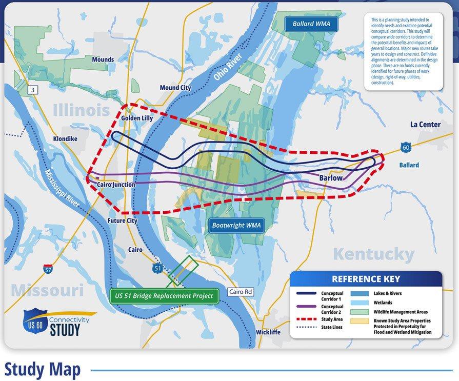
Both potential corridors would cut through Boatwright WMA in western Kentucky.
Likewise, the Kentucky chapter of Backcountry Hunters and Anglers voiced concern about the study on its website.
“Located in the midst of a major waterfowl flyway, the nearly 9,000-acre Boatwright WMA is one of the best public-land waterfowl hunting options in the state, and this project will have a dramatic impact on this and future generations of Kentuckians,” an article on the site said. “If the proposal through the WMA was accepted, it would permanently alter key wetlands, as well as a very popular public hunting, wildlife viewing, fishing, and access area.”
The study began after lawmakers requested information about the potential impacts of a more direct route between I-24 in Paducah, Kentucky, and I-57, north of Cairo, Illinois, according to a wkms.com article written by Derek Operle.
The first conceptual corridor would cost about $1.3 billion and cover 9.9 miles, affecting 23 acres of Boatwright WMA, 91 acres of wetlands, and 4,972 linear feet of streams, according to a corridor comparison chart in the DU-Kentucky email. The second conceptual corridor would cost $1.2 billion and cover 10.5 miles, affecting 68 acres of Boatwright WMA, 55 acres of wetlands, and 4,118 linear feet of streams. Replacing the U.S. Highway 51 bridge — which was built more than 80 years ago and is now obsolete and structurally deficient, according to the wkms.com article — would cost $3.83 million and cover just 1.9 miles. It would not affect Boatwright WMA but would impact 9 acres of wetlands and 598 linear feet of streams.
Recent public meetings have let citizens comment about the concepts. A final report from the study is slated to be forwarded to state lawmakers in February.
Boatwright WMA covers about 8,847 acres east of the Ohio River in western Kentucky. It’s comprised of about 53.9% wetlands, 35.8% open land, 8.5% open water, and 1.9% forest.
Don’t Miss: Is Duck Hunting Really in Decline?